Drainage System NCERT Class 11 Geography (India: Physical Environment)
1. MCQs with Reasons
| Q.No. | Question | Correct Answer | Reason |
|---|---|---|---|
| (i) | Which river is known as the Sorrow of Bengal? | (c) The Kosi 🌊 | The Kosi frequently changes its course in Bihar and West Bengal, causing massive floods every year—hence the nickname. |
| (ii) | Largest river basin in India | (c) The Ganga 🌏 | The Ganga drains an area of about 8.6 lakh sq. km, the largest in India, supporting millions through agriculture and water use. |
| (iii) | Not included in Panchnad | (c) The Indus 🏞️ | Panchnad means “five rivers” of Punjab—Sutlej, Beas, Ravi, Chenab, Jhelum. The Indus is the main river, not part of this confluence group. |
| (iv) | Flows in a rift valley | (b) The Narmada ⛰️ | Narmada flows west through a rift valley between Vindhya and Satpura ranges—formed by tectonic forces. |
| (v) | Confluence of Alaknanda & Bhagirathi | (d) Deva Prayag 🙏 | At Devprayag, in Uttarakhand, the Alaknanda and Bhagirathi meet to form the holy Ganga River. |
2. Differences
(i) River Basin vs. Watershed
| Aspect | River Basin 🌏 | Watershed 💧 |
|---|---|---|
| 1. Size | Large area drained by a river & its tributaries | Smaller area drained by a stream |
| 2. Scale | Macro-level | Micro-level |
| 3. Boundaries | Formed by highlands/mountains between basins | Formed by ridges or small hills |
| 4. Examples | Ganga Basin | A pond’s catchment area |
| 5. Water Flow | Main river + tributaries | Only one main stream |
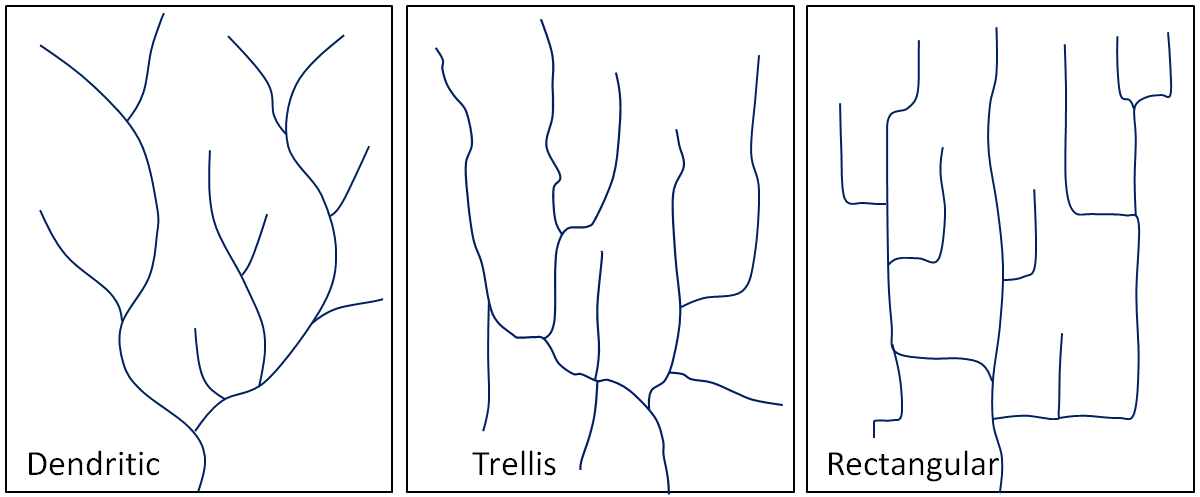
(ii) Dendritic vs. Trellis Drainage Pattern
| Aspect | Dendritic 🌳 | Trellis 🪢 |
|---|---|---|
| 1. Shape | Tree-like pattern | Rectangular/block pattern |
| 2. Cause | Uniform rock resistance | Alternating hard & soft rocks |
| 3. Main Stream | No specific control by rock structure | Main streams run parallel |
| 4. Joining Tributaries | Join main river at any angle | Join main river at nearly right angles |
| 5. Examples | Ganga River | Rivers in the Chotanagpur plateau |
(iii) Radial vs. Centripetal Drainage Pattern
| Aspect | Radial ☀️ | Centripetal 🎯 |
|---|---|---|
| 1. Direction of Flow | Outward from central high point | Inward towards central depression |
| 2. Landform | Conical hills/volcanoes | Basins/lakes |
| 3. Water Spread | Away from centre | Towards the centre |
| 4. Examples | Rivers from Amarkantak Hills | Sambhar Lake drainage |
| 5. Cause | High elevation at centre | Low elevation at centre |
(iv) Delta vs. Estuary
| Aspect | Delta 🔺 | Estuary 🌊 |
|---|---|---|
| 1. Formation | By deposition of sediments | By tidal action, no delta formation |
| 2. Shape | Triangular fan-shaped | Funnel-shaped |
| 3. Suitable for | Agriculture | Ports/harbours |
| 4. Examples | Ganga-Brahmaputra Delta | Narmada Estuary |
| 5. Sediment Load | High | Low (carried into sea) |
ALTERNATE
1. River Basin vs. Watershed
A river basin is a large geographical area drained by a main river and all its tributaries. It can cover thousands of square kilometres, for example, the Ganga Basin. A watershed, on the other hand, is much smaller—it is the catchment area for a single stream or a small river. The boundaries of a river basin are marked by high mountains or ridges between basins, while a watershed’s boundary is usually a small ridge or hill. River basins operate on a macro scale, whereas watersheds are micro-scale drainage areas. In short, every river basin is made up of many smaller watersheds. 🌊
2. Dendritic vs. Trellis Drainage Pattern
In a dendritic drainage pattern, streams branch out like the limbs of a tree, joining the main river at irregular angles. This pattern develops in regions where the rock type is uniform and does not strongly control the river’s direction. In a trellis pattern, the main rivers run parallel to each other, with short tributaries joining them at nearly right angles. This pattern forms in areas with alternating hard and soft rock bands, where softer rocks are eroded more easily, creating parallel valleys. 🌳🪢
3. Radial vs. Centripetal Drainage Pattern
Radial drainage occurs when rivers flow outward from a central high point such as a volcano, dome, or hill—examples include rivers from the Amarkantak Hills. In centripetal drainage, rivers flow inward from all directions towards a central low area, like a basin or depression—examples include the drainage into Sambhar Lake. The key difference is that radial patterns spread water away from the centre, while centripetal patterns collect water towards the centre. ☀️🎯


4. Delta vs. Estuary
A delta is a triangular or fan-shaped landform created by the deposition of sediments at the mouth of a river. It usually forms in slow-moving water where the river meets the sea, such as the Ganga-Brahmaputra Delta. An estuary, in contrast, is a funnel-shaped mouth of a river where freshwater mixes with seawater, often influenced by tides. Deltas are fertile and support agriculture, while estuaries are good for ports and harbours. Rivers with high sediment load form deltas, while those with strong tidal currents usually form estuaries. 🔺🌊


(i) Socio-economic advantages of inter-linking rivers in India
Inter-linking rivers helps transfer surplus water to water-deficit regions, solving floods and droughts. It improves irrigation, boosts farmers’ productivity, supplies drinking water, fosters inland water transport, and supports hydroelectricity and fisheries—thus enhancing regional economic growth.
(ii) Three characteristics of Peninsular rivers
Peninsular rivers are shorter and fewer in number, with fixed courses and well-adjusted valleys. They depend mainly on monsoon rainfall, making them seasonal. Mostly older rivers with graded profiles, they have relatively smaller basins and shallower, broad valleys.
Q4(i) What are the important characteristic features of North Indian rivers? How are these different from Peninsular rivers?
Characteristics of North Indian Rivers 🏔️
- Origin in the Himalayas – Most arise from glaciers and snowfields.
- Perennial Flow – Fed by both snowmelt and rainfall, ensuring water throughout the year.
- Long Courses – Travel great distances, creating vast drainage basins.
- Fertile Plains – Deposit nutrient-rich alluvium, forming extensive floodplains.
- Meandering Nature – Often change course and create oxbow lakes.
- High Sediment Load – Carry large amounts of silt from mountains.
- Deltas Formation – End by forming large deltas (e.g., Ganga-Brahmaputra Delta).
Differences Between North Indian and Peninsular Rivers
| Feature | North Indian Rivers 🏔️ | Peninsular Rivers 🪨 |
|---|---|---|
| Origin | Himalayas (snow + rain) | Western Ghats / Central Highlands |
| Flow | Perennial (water all year) | Seasonal (mainly monsoon-fed) |
| Length | Very long with large basins | Shorter with smaller basins |
| Nature | Young, active, meandering | Old, stable, straight courses |
| Bedrock | Flow over alluvial plains | Flow over hard, rocky terrain |
| Examples | Ganga, Yamuna, Brahmaputra | Godavari, Krishna, Narmada |
Q4(ii) Suppose you are travelling from Haridwar to Siliguri along the foothills of the Himalayas. Name the important rivers you will come across. Describe the characteristics of any one of them.
Important Rivers Along the Route 🚗🌊
While travelling from Haridwar (Uttarakhand) to Siliguri (West Bengal) along the Himalayan foothills, you may come across:
- Ganga
- Ramganga
- Kosi
- Gandak
- Kamla
- Bagmati
- Teesta
Example – The Ganga River 🌊🙏
- Origin – Emerges from the Gangotri Glacier in Uttarakhand as Bhagirathi.
- Length – About 2,525 km, one of the longest rivers in India.
- Drainage Basin – Covers vast fertile plains of north India.
- Perennial Nature – Fed by glaciers and monsoon rains.
- Economic Importance – Supports irrigation, transport, fishing, and religious activities.
- Delta Formation – Forms the Sundarbans Delta, the largest in the world.
thankyou….