Resources and Development class 10th
1) Big Picture (for quick teaching) 🎯
- A resource is anything useful to people that is technologically accessible, economically feasible, and culturally acceptable. 🛠️💰👨👩👧👦
- Wise use → resource planning + sustainable development (use today without harming tomorrow). 🌱
- India’s land varies: plains ~43%, mountains ~30%, plateaus ~27%—so resources are unevenly distributed, making planning essential. 🗺️⚖️
- Soils of India (6 types): Alluvial, Black (Regur), Red & Yellow, Laterite, Arid (Desert), Forest/Mountain—each with distinct properties, crops & locations. 🌾🧪
- Land degradation (from deforestation, overgrazing, mining, over-irrigation etc.) must be checked with afforestation, terrace farming, shelter belts, controlled grazing, treating effluents, etc. 🌳⛰️🌬️

2) Core Ideas & Classifications 🧭
| Concept | What it means (kid-friendly) | Examples / Notes |
|---|---|---|
| Resource 🧰 | Something that meets human needs and is usable with current tech, money, and culture. | Land, water, soil, minerals, forests, people’s skills. |
| By Origin 🌱🔩 | Biotic (living) vs Abiotic (non-living) | Biotic: plants, animals 👩🌾; Abiotic: minerals, metals ⛏️ |
| By Exhaustibility 🔄 | Renewable ♻️ vs Non-renewable 🛑 | Renewable: solar, wind; Non-renewable: coal, petroleum |
| By Ownership 🏠 | Individual, Community, National, International | Farmer’s field; village grazing land; minerals under the State; high seas beyond 200 NM |
| By Status of Development 🚦 | Potential, Developed, Stock, Reserves | Potential solar in deserts ☀️; Developed coalfields ⛏️; Stock (not usable yet with present tech); Reserves (usable, kept for future) |
Sustainable Development & Agenda-21: Global plan from the 1992 Rio Summit urging countries and local governments to craft their own sustainability agendas (fight environmental damage, poverty, disease). 🌎🤝 NCERT
3) Why India needs Resource Planning 🧑🏫🗺️
| Step | What teachers can say | Classroom cue |
|---|---|---|
| (i) Identification & mapping | “First, find what/where/how much we have.” | Use India maps; soil & mineral atlases |
| (ii) Evolving structure | “Match resources with technology, institutions, and skills.” | Talk about irrigation, storage, training |
| (iii) Balanced plan | “Use without overusing; share benefits fairly.” | Link to sustainability + local needs |
India’s diverse relief (plains ~43%, mountains ~30%, plateaus ~27%) explains why some regions are rich in some resources and poor in others—planning brings equity + efficiency. 🧩⚖️ NCERT
4) Land: Use, Problems & Protection 🏞️
4A) Land Use Categories (NCERT list; explain qualitatively)
Forest, Land under non-agricultural uses (roads, settlements, industries), Barren & unculturable land, Permanent pastures & grazing land, Miscellaneous tree crops & groves, Wasteland, Fallow (current & other), Net sown area. 🗂️
(NCERT presents land categories and emphasises careful use; use your state’s latest economic survey for local numbers if needed.) NCERT
4B) Land Degradation: Causes & Fixes 🛠️
| Cause 😬 | Typical Regions (examples) | What happens | NCERT-backed Remedies 😇 |
|---|---|---|---|
| Deforestation, mining & quarrying ⛏️ | Jharkhand, Chhattisgarh, MP, Odisha | Scars, over-burden, erosion | Afforestation, regulate mining, reclaim pits |
| Overgrazing 🐄 | Gujarat, Rajasthan, MP, Maharashtra | Vegetation loss → erosion | Grazing management, rotational grazing |
| Over-irrigation 🚿 | Punjab, Haryana, W. UP | Water-logging → salinity/alkalinity | Lining canals, drainage, judicious irrigation |
| Industrial effluents & dust 🏭 | Industrial belts | Soil/water pollution, infiltration drops | Treat effluents, dust control, green buffers |
| Wind/Water erosion in arid slopes 🌬️🌧️ | Western India, badland areas | Topsoil blown/washed away | Shelter belts, strip cropping, contour ploughing, terracing, dune stabilisation with thorny shrubs |
These are stated with state-examples directly in NCERT. 🌿 NCERT
5) Soil as a Resource 🌾
5A) How soil forms (kid-friendly) 🪨🌧️🌡️🌿⏳
- Needs time (millions of years) to make a few cm!
- Driven by parent rock, relief, climate, vegetation/organisms, and time.
- Soil profile: Topsoil (humus-rich) → subsoil → weathered rock → bedrock. 📚 NCERT
5B) India’s Major Soil Types (teach with a big wall chart) 🗺️
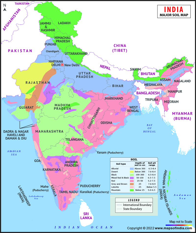
| Soil Type | Where in India 🗺️ | How it looks/behaves 🔬 | Best for 🌱 | Challenges & Care 🛠️ |
|---|---|---|---|---|
| Alluvial 🏞️ | Northern Plains (Indus-Ganga-Brahmaputra); also deltas of Mahanadi, Godavari, Krishna, Kaveri; narrow corridor into Rajasthan-Gujarat | Sand-silt-clay mix; Khadar (new, finer, more fertile) vs Bangar (older, more kankar); very fertile | Rice, wheat, sugarcane, pulses | Alkaline in drier parts—needs proper irrigation & treatment |
| Black (Regur) 🖤 | Deccan Trap: Maharashtra, Saurashtra, Malwa, MP, Chhattisgarh; along Godavari & Krishna valleys | Clayey, high moisture-holding; rich in CaCO₃, Mg, potash, lime; cracks in summer | Cotton, soyabean, citrus | Sticky when wet; plough right after first showers or pre-monsoon |
| Red & Yellow 🧱 | Crystalline igneous areas of E & S Deccan; parts of Odisha, Chhattisgarh, S Ganga plain, piedmont of W. Ghats | Reddish (iron diffusion); yellow when hydrated | Millets, pulses, oilseeds, groundnut | Lower humus—add manure; manage erosion |
| Laterite 🧱☔ | Southern states, W. Ghats (MH), Odisha, parts of WB & NE; hilly areas of KA-KL-TN | From intense leaching in alternating wet-dry climate; acidic (pH<6); nutrient-poor unless under dense forests | Tea, coffee (on hills with care), cashew (red laterite in TN/AP/KL) | Prone to erosion—terracing, bunding, organic matter |
| Arid (Desert) 🏜️ | Western Rajasthan etc. | Red-brown, sandy, saline; kankar layer at depth blocks infiltration | After irrigation: bajra, guar | Desalination, windbreaks, proper irrigation |
| Forest/Mountain 🌲⛰️ | Himalayan & hill states | Loamy/silty in valleys; coarse on upper slopes; acidic, low humus in snow zones | Maize, temperate fruits (valleys) | Denudation; terrace farming, contour bunds |
All attributes above are straight from NCERT descriptions. 📙 NCERT
6) Soil Erosion & Conservation 🧯
| Erosion Type | Easy demo for class | What it causes | NCERT Remedy (say & show) |
|---|---|---|---|
| Gully erosion 🕳️ | Pour water through clay mound → channels | “Badlands” (e.g., Chambal ravines) | Plug gullies, plant grasses/trees |
| Sheet erosion 🧻 | Tilt tray of soil + light water → thin top wash | Loss of topsoil | Contour ploughing, strip cropping |
| Wind erosion 🌬️ | Fan over dry sand | Blows away fine soil | Shelter belts (rows of trees), stubble mulch |
| Slope wash ⛰️ | Spray water down sloped tray | Fast runoff channels | Terrace farming (steps on slopes) |
NCERT highlights contour ploughing, terracing, strip cropping, and shelter belts as key practices; shelter belts helped stabilise sand dunes in western India. 🌾🌳 NCERT
📘 Chapter 1 – Resources and Development
❓ Multiple Choice Questions (MCQs) with Answers & Explanations
Q1. Which one of the following type of resource is iron ore?
a) Renewable
b) Biotic
c) Flow
d) Non-renewable


✅ Answer: (d) Non-renewable
👉 Iron ore cannot be renewed within a human lifetime. Once mined and used, it takes millions of years to form again. That’s why it is non-renewable.
Q2. Under which of the following type of resource can tidal energy be put?
a) Replenishable
b) Human-made
c) Abiotic
d) Non-recyclable
✅ Answer: (a) Replenishable
👉 Tidal energy is produced by the movement of sea water (tides). As tides keep coming again and again, this energy is renewable/replenishable.
Q3. Which one of the following is the main cause of land degradation in Punjab?
a) Intensive cultivation
b) Deforestation
c) Over-irrigation
d) Overgrazing
✅ Answer: (c) Over-irrigation
👉 In Punjab, farmers use too much water for irrigation. This leads to waterlogging and salinity, which degrades the land.
Q4. In which one of the following states is terrace cultivation practiced?
a) Punjab
b) Haryana
c) Plains of Uttar Pradesh
d) Uttarakhand
✅ Answer: (d) Uttarakhand
👉 In hilly areas like Uttarakhand, farmers cut terraces (steps) on the slopes of mountains to stop soil erosion and grow crops.
Q5. In which of the following states is black soil found?
a) Jammu and Kashmir
b) Maharashtra
c) Rajasthan
d) Jharkhand
✅ Answer: (b) Maharashtra
👉 Black soil is also called Regur soil or Cotton soil. It is found in Maharashtra, Madhya Pradesh, Gujarat etc., and is very good for growing cotton.
2. Answer in about 30 words
(i) Name three states having black soil and the crop which is mainly grown in it.
Answer:
Black soil is found primarily in Maharashtra, Gujarat, and Madhya Pradesh. This fertile soil is ideally suited for growing cotton, making it the main commercial crop in these states.
(ii) What type of soil is found in the river deltas of the eastern coast? Give three main features of this type of soil.
Answer:
Alluvial soil is found in the river deltas of the eastern coast. It is very fertile, contains a mix of sand, silt, and clay, and is rich in nutrients like potash, lime, and phosphoric acid—ideal for paddy and sugarcane.
(iii) What steps can be taken to control soil erosion in hilly areas?
Answer:
To control soil erosion in hilly areas, techniques such as contour ploughing, terrace farming, and strip cropping—with strips of grass between crop rows—should be implemented to reduce runoff and soil loss.
(iv) What are the biotic and abiotic resources? Give some examples.
Answer:
Biotic resources originate from living organisms, e.g., plants, animals, fish, and human beings. Abiotic resources are non-living, e.g., water, minerals, metals, wind, and solar energy.
3. Answer in about 120 words
(i) Explain the land use pattern in India and why has the land under forest not increased much since 1960-61?
Answer:
India’s land use patterns include agricultural land, forests, grazing areas, wastelands, fallow land, and land under non-agricultural uses. Agricultural land occupies a major share, followed by forests. Since 1960-61, forest cover has not significantly increased due to growing demand for agricultural land, urbanisation, infrastructure development, and slow afforestation. Competing demands of food security and development, along with population pressure, have limited forest expansion. This highlights the need for balanced resource planning and sustainable land management policies to conserve forest areas while supporting development.
(ii) How have technical and economic development led to more consumption of resources?
Answer:
Technical and economic development have raised living standards and industrial output, increasing resource consumption. Improved technology enables extraction of more resources (like fossil fuels and minerals), while economic growth fuels demand for energy, materials, and infrastructure. As sectors like agriculture, transport, and construction expand, the pressure on natural resources intensifies, leading to overexploitation and environmental degradation. Without sustainable management and planning, technological and economic progress can strain ecosystems and deplete renewable and non-renewable resources.